Middle East Tectonics: Applications of Geographic Information
Systems (GIS)
by
Dogan Seber, Marisa Vallve, Eric Sandvol, David
Steer,
and Muawia Barazangi
Institute for the Study of the Continents, Cornell University,
Snee Hall, Ithaca, NY 14853-1504. e-mail: seber@geology.cornell.edu
 ABSTRACT
The Middle East region incorporates all known types of major plate
boundaries in its territory as well as significant active intraplate deformation.
Until recently, understanding the tectonics in this complex region has
been hindered by a relative lack of data and the complexity of the geologic
and tectonic problems. Even with the increase in the amount of data in
the past decade or so, the complexities of the region require multidisciplinary
approach to understand the geology and tectonics. In order to handle large,
multidisciplinary data sets with varying quality and resolution, we have
adopted a Geographic Information System (GIS) approach for construction
of a multi-purpose database to look at these problems in a comprehensive
and unconventional way. Here, we present new compilation maps of surficial
tectonic features and of depth to the Moho for the Middle East, and describe
a cross-section tool to work with data of this type in a GIS format. Interested
parties can access these maps at our web site at http://atlas.geo.cornell.edu.
ABSTRACT
The Middle East region incorporates all known types of major plate
boundaries in its territory as well as significant active intraplate deformation.
Until recently, understanding the tectonics in this complex region has
been hindered by a relative lack of data and the complexity of the geologic
and tectonic problems. Even with the increase in the amount of data in
the past decade or so, the complexities of the region require multidisciplinary
approach to understand the geology and tectonics. In order to handle large,
multidisciplinary data sets with varying quality and resolution, we have
adopted a Geographic Information System (GIS) approach for construction
of a multi-purpose database to look at these problems in a comprehensive
and unconventional way. Here, we present new compilation maps of surficial
tectonic features and of depth to the Moho for the Middle East, and describe
a cross-section tool to work with data of this type in a GIS format. Interested
parties can access these maps at our web site at http://atlas.geo.cornell.edu.
INTRODUCTION
At present, the earth sciences are undergoing a revolution. Evidence
comes from collection to analysis of data, interpretation and publication.
Classical approaches are being increasingly supplemented by digital techniques,
i.e., analog maps by digital counterparts, air 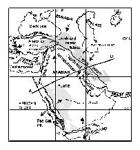 photos
by high resolution satellite imagery, hand collection of field data by
GPS receivers and lap top computers, simple modeling by computer modeling
using sophisticated software, and electronic publication of results. This
development is an inevitable outcome of modern technology. However, the
revolution is not without problems. Already somewhat chaotically organized
databases are appearing in the "digital world" owing to problems
like data accessibility and formats. Geographic Information Systems (GIS)
provide a means to eliminate these problems and to keep data in an organized
and centralized system (see also Walker et al., 1996 in March 1996 issue
of GSA TODAY). Structured properly, well engineered databases are easy
to use, update, modify, manage, distribute and exchange. One of the common
misconceptions about GIS database development is that it is primarily a
mapping tool. Although the outputs are often in map form, the main use
of GIS is to analyze, search, manipulate, and select databases for a specific
purpose. The use of GIS systems opens new avenues for comprehensive studies
and solving complex problems related to integrated and dynamic earth systems.
Earth sciences, by their very nature, are among the most suitable disciplines
for GIS applications.
photos
by high resolution satellite imagery, hand collection of field data by
GPS receivers and lap top computers, simple modeling by computer modeling
using sophisticated software, and electronic publication of results. This
development is an inevitable outcome of modern technology. However, the
revolution is not without problems. Already somewhat chaotically organized
databases are appearing in the "digital world" owing to problems
like data accessibility and formats. Geographic Information Systems (GIS)
provide a means to eliminate these problems and to keep data in an organized
and centralized system (see also Walker et al., 1996 in March 1996 issue
of GSA TODAY). Structured properly, well engineered databases are easy
to use, update, modify, manage, distribute and exchange. One of the common
misconceptions about GIS database development is that it is primarily a
mapping tool. Although the outputs are often in map form, the main use
of GIS is to analyze, search, manipulate, and select databases for a specific
purpose. The use of GIS systems opens new avenues for comprehensive studies
and solving complex problems related to integrated and dynamic earth systems.
Earth sciences, by their very nature, are among the most suitable disciplines
for GIS applications.
BUILDING A COMPREHENSIVE DATABASE FOR THE MIDDLE EAST
In this paper, we apply GIS technology to regional scale tectonic problems
of the Middle East. To 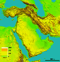 do
this, we are developing a comprehensive database at a resolution of 1:1,000,000
scale which can be used as both a scientific and educational tool. Developing
such a database system for multiple users is most advantageous if easy
to use tools for accessing and manipulating data sets are built into the
system so that scientists can use the database in innovative ways to make
research advances. The principal reasons for constructing this database
in the Middle East are to help in the recently signed global Comprehensive
Test Ban Treaty (CTBT), especially in monitoring and verification efforts
(see Barazangi et al. 1996), and in studying the complex tectonic/geologic
problems of the region with multidisciplinary approaches. Such databases
will also have impact in natural hazard evaluation, such as understanding
the earthquake occurrences in the region and seismic risk assessment. These
data sets can also be used in classrooms as educational tools. Below, we
present some examples of uses of our databases.
do
this, we are developing a comprehensive database at a resolution of 1:1,000,000
scale which can be used as both a scientific and educational tool. Developing
such a database system for multiple users is most advantageous if easy
to use tools for accessing and manipulating data sets are built into the
system so that scientists can use the database in innovative ways to make
research advances. The principal reasons for constructing this database
in the Middle East are to help in the recently signed global Comprehensive
Test Ban Treaty (CTBT), especially in monitoring and verification efforts
(see Barazangi et al. 1996), and in studying the complex tectonic/geologic
problems of the region with multidisciplinary approaches. Such databases
will also have impact in natural hazard evaluation, such as understanding
the earthquake occurrences in the region and seismic risk assessment. These
data sets can also be used in classrooms as educational tools. Below, we
present some examples of uses of our databases.
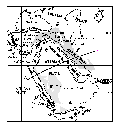
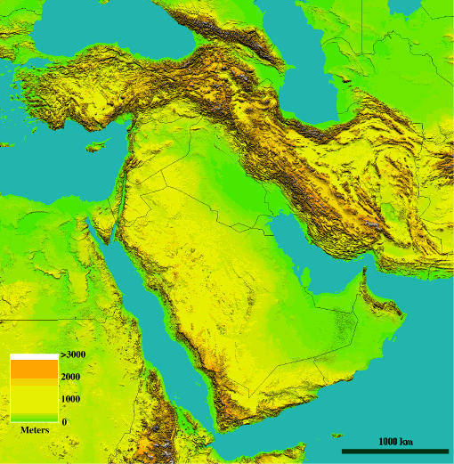
An Improved Tectonic Map of the Middle East Among the data sets available
to us is a high resolution (~ 90m ) digital topographic map of the Middle
East obtained from the Defense Mapping Agency (DMA). Digital Elevation
Models (DEM) like these provide highly accurate elevation information that
can be used as a guide in defining boundaries of tectonic units, especially
those related to young (i.e., Quaternary) deformation. Using the digital
topography data, we redefined the boundaries of the previously outlined
main tectonic units, such as the North and East Anatolian faults. We also
defined a new boundary for the Turkish - Iranian plateau (see Figures 1-3).
These main tectonic units can be seen by comparing the GIS based map in
Figure 1 with the tectonic map in Figure 2. As shown, the Middle East region
incorporates all known types of major plate boundaries around the borders
of the Arabian plate (e.g., Dewey and Sengor, 1979). To the south along
the Red Sea and the Gulf of Aden new oceans are opening (see Cochran, 1983;
Le Pichon and Francheteau, 1978). To the north and east, continental collision
is occurring along the Bitlis suture zone in southern Turkey (Sengor and
Kid, 1979; Sengor et al., 1985) and the Zagros suture zone in western Iran
(Snyder and Barazangi, 1986; Ni and Barazangi, 1986). The current counter-clockwise
rotation and northward motion of the Arabian plate relative to Eurasia
is accommodated along these collision zones. Well developed arc volcanoes
and a foreland basin along the entire Zagros mountain system indicate Neogene
subduction in this region. Although a similar volcanic arc and foreland
basin are not easily identified along the Bitlis suture, a Neogene subduction
zone is also inferred in this region, especially in southeast Turkey. To
the northwest, the Dead Sea fault system manifests itself as a left-lateral
strike-slip plate boundary that extends approximately 900 km along the
boundary between the Arabian and African/Levantine plates (Garfunkel, 1981;
Girdler, 1990; and Chaimov et al., 1990). Other major strike-slip zones
are the right-lateral North Anatolian in northern Turkey and the left-lateral
East Anatolian fault in eastern Turkey, which respectively form the northern
and eastern boundaries of the Anatolian block. These faults developed to
accommodate the escape of the Anatolian block towards the west in response
to the collision of Arabia and Asia (Sengor et al., 1985). A consequence
of the collision between the Arabian and Eurasian plates is the development
of the high plateau in eastern Turkey and northwestern Iran (Turkish and
Iranian Plateau) which covers a wide zone behind the main Zagros and Bitlis
suture zones. We used the high resolution topographic data to map the boundaries
of this plateau by following the 1500 m elevation contour. This value represents
the maximum elevation or base level of the plateau that defines a continuos
elevated surface covering the entire area. Although the mechanism supporting
this high plateau is not well understood, extensive volcanism and strong
seismic shear wave attenuation in the mantle lithosphere beneath the plateau
(e.g., Kadinsky-Cade et al., 1981) do suggest a thermal component. Further
work is needed to fully understand the crustal and upper mantle structures
of this region. In the western part of the Arabian platfrom, east of the
Red Sea, lies a shield area where Precambrian age of crystalline rocks
are exposed tocover a large area (Figure 2). Although this region is called
the Arabian Shield, it certainly has disctinct features that do not exist
in other shield areas. The Arabian Shield has been subjected to rifting
that formed the Red Sea. The rifting still continues today. The Shield
certainly does not fit in the general definition of shied regions which
are identified as regions of long term tectonic stability. These variations
from a typical shield structure manifests itself in geophysical data as
well. This shield region, in contrast to other shield regions, is characterized
by very low seismic crustal Q values (e.g., Seber and Mitchell, 1992),
which are usually interpreted to result from high tectonic activity and/or
eleveted temperature. High Cenozoic volcanic activity within the shield
area is also an indication of departure from a typical shield environment
(e.g., Camp and Roobol, 1992). In addition to the boundaries of the major
tectonic units, the map in Figure 1 also has other types of digitized data.
In particular, secondary faults, volcanic rock distributions, ophiolites,
basement outcrops, and basin locations have been compiled from several
tectonic and geologic maps, such as the Seismotectonic Map of the Middle
East published by the Geological Survey of Iran, Geologic Map of Syria
of the Syrian Arab Republic's Ministrity of Petroleum and Mineral Resources,
and the Active Fault Map of Turkey of the General Directorate of Mineral
Research and Exploration of Turkey. These geologic features have all been
assigned attributes defining their properties. Using this GIS data system,
one can then, for example, select faults longer or shorter than any given
length, display faults relative to any spatial data in the database or
choose active faults and volcanoes from a given region to study spatial
correlation among data sets. In this way, a first order correlation between
topography, faults, and seismicity has been found that suggests that most
of the faults shown in Figure 1 are still active and that the topography
is in large part shaped by active tectonic processes. High resolution satellite
imagery and field geology data can also be incorporated in the database
system to study the effects of erosion on topography. Other prominent problems
for study in the region are volcanic activity in both tectonically active
and platform-like environments, the complex patterns of seismicity, and
the variations in crustal structure.
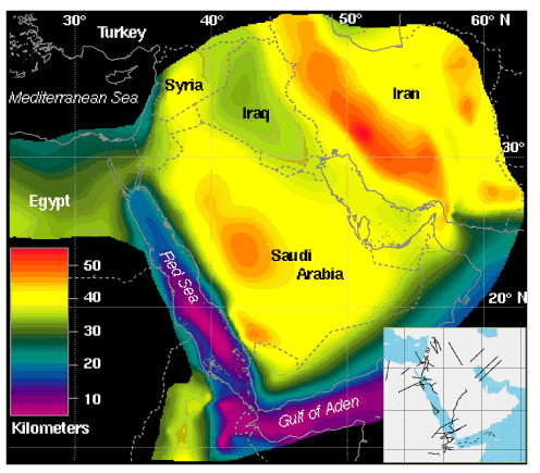
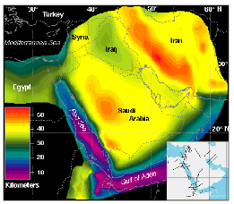 A
New Moho Map of the Middle East One of the least known geological features
in the Middle East region is the thickness of the continental crust , that
is the depth to the crust-mantle boundary or Moho. To constrain Moho depth
in this region, we have digitized over 50 interpreted crustal scale refraction
and gravity profiles (Figure 4) from the published literature. All boundaries
have been assigned specific attribute names like basement and Moho. To
this database, we have added Moho depth estimations obtained using a single
station technique (e.g., Sandvol et al., 1996). Moho depth values from
surface wave tomographic studies (Ghalib, 1992) and interpretations of
Bouguer gravity data in Iran (Dehghani, 1981) were also incorporated. The
new, more accurate Moho map in Figure 4 was made by selecting and gridding
all of the depth to Moho values in the database. In regions where data
are limited, Moho depth has been determined by interpolation from the nearest
data points. Examination of the map in Figure 4 points to a number of first
order characteristics of the crust surrounding and within the Arabian plate.
First, the thickest crust occurs beneath the Zagros mountains in Iran where
continental collision is taking place. Second, the thinnest crust occurs
beneath the southern Red Sea where new oceanic crust is forming. Third,
the crustal thickness beneath the Arabian shield is about 40-45 km. The
thickning beneath the Arabian Shield is constrained by a single profile,
and hence this result should be taken cautiously. New seismological data
have been collected from this region and the results of which will provide
additional constraints in Moho depth in this region. Fourth, the crust
is very thin (~ 8 km) beneath the Afar triangle of Africa, just west of
the southern Red Sea. This region is thought to be underlain by either
an oceanic type crust or a new igneous crust (Soriot and Brun, 1992)
A
New Moho Map of the Middle East One of the least known geological features
in the Middle East region is the thickness of the continental crust , that
is the depth to the crust-mantle boundary or Moho. To constrain Moho depth
in this region, we have digitized over 50 interpreted crustal scale refraction
and gravity profiles (Figure 4) from the published literature. All boundaries
have been assigned specific attribute names like basement and Moho. To
this database, we have added Moho depth estimations obtained using a single
station technique (e.g., Sandvol et al., 1996). Moho depth values from
surface wave tomographic studies (Ghalib, 1992) and interpretations of
Bouguer gravity data in Iran (Dehghani, 1981) were also incorporated. The
new, more accurate Moho map in Figure 4 was made by selecting and gridding
all of the depth to Moho values in the database. In regions where data
are limited, Moho depth has been determined by interpolation from the nearest
data points. Examination of the map in Figure 4 points to a number of first
order characteristics of the crust surrounding and within the Arabian plate.
First, the thickest crust occurs beneath the Zagros mountains in Iran where
continental collision is taking place. Second, the thinnest crust occurs
beneath the southern Red Sea where new oceanic crust is forming. Third,
the crustal thickness beneath the Arabian shield is about 40-45 km. The
thickning beneath the Arabian Shield is constrained by a single profile,
and hence this result should be taken cautiously. New seismological data
have been collected from this region and the results of which will provide
additional constraints in Moho depth in this region. Fourth, the crust
is very thin (~ 8 km) beneath the Afar triangle of Africa, just west of
the southern Red Sea. This region is thought to be underlain by either
an oceanic type crust or a new igneous crust (Soriot and Brun, 1992)
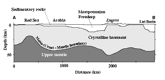
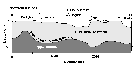 The
Profile Maker A tool called Profile Maker that we have developed to be
used with gridded databases aids in detailed studies of these crustal variations.
This tool extracts and draws a crustal scale cross section between any
two points within the area of data coverage. Any combination of topographic,
metamorphic basement, crustal thickness, seismic velocity, gravity or any
other available data can be incorporated in a two-D cross-section. These
profiles then can be used, for example, for seismic waveform or gravity
modeling, or for other research and teaching efforts. A cross-section using
this tool that incorporates topography, depth to metamorphic basement,
and crustal thickness is shown in Figure 5. The cross section shows the
thin crust in the Red Sea and the thick crust beneath the Zagros mountains
in comparison with the rest of the Arabian platform. The Mesopotamian foredeep
is also identifiable by the thickening of sediments toward the Zagros collision
zone.
The
Profile Maker A tool called Profile Maker that we have developed to be
used with gridded databases aids in detailed studies of these crustal variations.
This tool extracts and draws a crustal scale cross section between any
two points within the area of data coverage. Any combination of topographic,
metamorphic basement, crustal thickness, seismic velocity, gravity or any
other available data can be incorporated in a two-D cross-section. These
profiles then can be used, for example, for seismic waveform or gravity
modeling, or for other research and teaching efforts. A cross-section using
this tool that incorporates topography, depth to metamorphic basement,
and crustal thickness is shown in Figure 5. The cross section shows the
thin crust in the Red Sea and the thick crust beneath the Zagros mountains
in comparison with the rest of the Arabian platform. The Mesopotamian foredeep
is also identifiable by the thickening of sediments toward the Zagros collision
zone.
CONCLUSIONS As we progress into the digital technology age, proficient
ways of capturing, storing, organizing, manipulating, and updating data
sets have to be developed before we are overwhelmed by the amount, diversity,
and heterogeneity of the data. Clearly, GIS provides a convenient platform
for data collection, organization and research with multidisciplinary data
sets. As more groups adopt GIS applications, the earth sciences community
will be in a position to prepare a unified global database to conduct more
efficient, productive and rewarding scientific research. Such a database
platform will significantly impact the way we conduct research, teach and
educate future generations of earth scientists. This study shows that there
are significant scientific return on the efforts that are spent on putting
together such a GIS database. Using our Middle East GIS database we now
have a better understanding of the tectonics and crustal structure in this
region. Further information about our efforts on the Middle East database
as well as access to mentioned databases/tools is provided on the Internet
at http://atlas.geo.cornell.edu.
ACKNOWLEDGMENTS Research reported in this paper is supported
by the Department of Energy (DOE) contract F19628-95-C-0092. Institute
for the Study of the Continents (INSTOC) contribution No. 234. We thank
the Science Editor, Suzanne M. Kay, and reviewers T. Pavlis, and R. Reilinger
for constructive comments and suggestions.
REFERENCES CITED
Barazangi, M., Fielding, E. J., Isacks, B., and Seber, D., 1996, Geophysical
and geological databases and CTBT monitoring: A case study of the Middle
East, In Monitoring a Comprehensive Test Ban Treaty (eds. E.S. Husebye
and A.M. Dainty), Kluwer Academic Publishers, The Netherlands, 197-224.
Camp, V. E. and Roobol, M. J., 1992. Upwelling asthenosphere beneath
western Arabia and its regional implications, J. Geophy. Res., 97, 15255-15271.
Chaimov, T., Barazangi, M., Damen, A., Sawaf, T., and Gebran, A., 1990.
Crustal shortening in the Palmyride fold belt, Syria, and implications
for movement along the Dead Sea Fault system, Tectonics, 9, 1369-1386.
Cochran, J. R., 1983. A model for development of Red Sea, Am. Assoc.
Pet. Geol., 67, 41-69. Dehghani, Gholamali, 1981, Schwerefeld und Krustenaufbau
im Iran, Universitat Hamburg, pp. 74.
Dewey, J. F., and Sengor, A.M.C., 1979. Aegean and surrounding regions:
complex multiple and continuum tectonics in a convergent zone, Geol. Soc.
Am. Bull. 90, 84-92. Garfunkel, Z., 1981. Internal structure of the Dead
Sea leaky transform (rift) in relation to plate kinematics, Tectonophysics,
80, 81-108.
Ghalib, H. A. A., 1992, Seismic velocity structure and attenuation of
the Arabian plate, Ph.D. Thesis, pp. 314, St. Louis University, St. Louis,
USA. Girdler, R.W., 1990. The Dead Sea transform fault system, Tectonophysics,
180, 1-13.
Le Pichon, X., and J. Francheteau, 1978. A plate-tectonic analysis of
the Red Sea - Gulf of Aden area, Tectonophysics, 46, 369-406.
Kadinsky-Cade, C., M. Barazangi, J. Oliver, B. Isacks, 1981, Lateral
variations of high-frequency seismic wave propagation at regional distances
across the Turkish and Iranian plateaus, J. Geophy. Res., 86, 9377-9396.
Ni, J. and Barazangi, M., 1986. Seismotectonics of the Zagros continental
collision zone and a comparison with the Himalayas, Jour. Geophy. Res.,
91, 8205-8218.
Sandvol, E., Seber, D., Barazangi, M., 1996, Single-station receiver
function inversions in the Middle East and North Africa: A grid search
approach, Abstract, AGU fall meeting.
Seber, D. and Mitchell, B., 1992. Attenuation of surface waves accross
the Arabian peninsula, Tectonophysics, 204, 137-150.
Sengor, A.M.C., and W.S.F. Kid, 1979. Post-collisional tectonics of
the Turkish and Iranian plateaux and a comparision with Tibet, Tectonophysics,
55, 361-376.
Sengor, A.M.C., N. Gorur, and F. Saroglu, 1985, Strike-slip faulting
and related basin formation in zones of tectonic escape: Turkey as a case
study, in K.T. Biddle and N. Christe-Blick (eds.) Strike-slip deformation,
basin formation and sedimentation, Soc. Economic Paleontologist and mineralogists,
Special Publication, 37, 227-265.
Snyder, D., and Barazangi, M., 1986. Deep crustal structure and flexure
of the Arabian plate beneath the Zagros collisional mountain belt as inferred
from gravity observations, Tectonics, 5, 361-373, 1986.
Souriot, T. and Brun, J.P., 1992. Faulting and block rotation in the
Afar triangle, East Africa: The Danakil "crank-arm" model, Geology,
20, 911-914.
Walker, D. J, Black, R. A., Linn, J. K., Thomas, A. J., Wiseman, R.,
D'Attilio, M. G., 1996, Development of Geographic Information Systems-Oriented
Databases for Integrated Geological applications and Geophysical Applications,
GSA Today, 6, 1-7.
Figure Captions
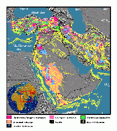
Figure 1. New map of the Middle East region showing locations
of major faults and ophiolites, regions of basement outcrop, and principal
areas of volcanism. Map is compiled from GIS data set that includes tectonic
and geologic maps of various scales from the different countries in the
region. See Figure 2 for tectonic interpretation. Background image is the
shaded relief map of topography shown in more detail in Figure 3. A clear
correlation between topographic features and faults suggests that most
of these faults are still active.
Figure 2. Simplified tectonic map of the Middle East showing
types of plate boudaries surrounding the Arabian Plate plate and location
of profile A-B in Figure 5. The extend of the plateau, plate boundaries
and faults have been modifed from earlier maps by incorporating topographic
information in Figure 3.
Figure 3. Shaded relief map showing topography of the Middle
East created using data obtained from the Defense Mapping Agency and the
USGS's 1 km global elevation model. Elevations range from sea level to
over 6000 meters in some localized peaks. Refer to Figure 2 for definitions
of tectonic units and to Figure 4 for geographic names..
Figure 4. New Moho map of the Middle East compiled by merging
more than 50 crustal scale profiles (see inset map) and additional information.
The deepest Moho is found beneath western Iran, whereas the shallowest
Moho is under the southern part of the Red Sea. Moho depth in most of the
Arabian plate is a little over 40 km. The inset map shows locations of
published profiles used in the compilation.
Figure 5. Crustal scale section showing how the crust-mantle
boundary and the thickness of sedimentary cover over basement changes on
a southwest to northeast profile across the Red Sea, the Arabian plate,
and the Zagros suture. Profile is along line A-B in Figure 2 and incorporates
basement depths from our Middle East GIS data base as well as information
shown on Figures 3 and 4.. Basement depths defined here is based on seismic
velocity information. The boundary at which seismic P-wave velocities reach
6 km/s is interpreted to represent the contact between the sedimentary
rocks and crytalline rocks. Note the effects of rifting and thinning of
the crust in the Red Sea in contrast with the thickening of foredeep sediments
and crust beneath the Zagros collision zone.
This paper was published in GSA Today February 1997 issue
 ABSTRACT
The Middle East region incorporates all known types of major plate
boundaries in its territory as well as significant active intraplate deformation.
Until recently, understanding the tectonics in this complex region has
been hindered by a relative lack of data and the complexity of the geologic
and tectonic problems. Even with the increase in the amount of data in
the past decade or so, the complexities of the region require multidisciplinary
approach to understand the geology and tectonics. In order to handle large,
multidisciplinary data sets with varying quality and resolution, we have
adopted a Geographic Information System (GIS) approach for construction
of a multi-purpose database to look at these problems in a comprehensive
and unconventional way. Here, we present new compilation maps of surficial
tectonic features and of depth to the Moho for the Middle East, and describe
a cross-section tool to work with data of this type in a GIS format. Interested
parties can access these maps at our web site at http://atlas.geo.cornell.edu.
ABSTRACT
The Middle East region incorporates all known types of major plate
boundaries in its territory as well as significant active intraplate deformation.
Until recently, understanding the tectonics in this complex region has
been hindered by a relative lack of data and the complexity of the geologic
and tectonic problems. Even with the increase in the amount of data in
the past decade or so, the complexities of the region require multidisciplinary
approach to understand the geology and tectonics. In order to handle large,
multidisciplinary data sets with varying quality and resolution, we have
adopted a Geographic Information System (GIS) approach for construction
of a multi-purpose database to look at these problems in a comprehensive
and unconventional way. Here, we present new compilation maps of surficial
tectonic features and of depth to the Moho for the Middle East, and describe
a cross-section tool to work with data of this type in a GIS format. Interested
parties can access these maps at our web site at http://atlas.geo.cornell.edu.