 Table of Contents
Table of Contents
Crustal and lithospheric structure variations as well as major topographic relief along seismic wave propagation paths and at the source and receiver sites are crucial information to understand the excitation and propagation of high-frequency regional seismic phases, and other aspects of the problems of verification and estimation of the yield of nuclear and chemical explosions. Our objective is to collect and organize all available seismological, geophysical, topographical, and geological datasets for the Middle East and North Africa into a digital information system that is accessible via the Internet from Cornell and can be utilized by display programs running at the Center for Monitoring Research (CMR) and by other ARPA/AFOSR/DOE/AFTAC researchers.
We began a comprehensive effort to compile and digitize information on the crustal structure of the Middle East and North Africa to expand our existing database for Eurasia developed under previous contracts. Our first work was in the Middle East where we located and digitized published data on the depth to Moho and basement and crustal velocity and density structures, primarily as interpreted from seismic refraction, gravity, and drill hole datasets. We also maintain a comprehensive bibliography of all the relevant references in a computer database. All data are stored in our Arc/Info Geographic Information System (GIS). The format of the files being released is detailed in Appendix I.
We have continued to add more information into our database for our goal of a complete crustal structure database as well as other types of geophysical and geological databases for the Middle East and North Africa. In this data release, we present some of the data interpretations country by country, including Egypt, Iran, Israel, Jordan, and Saudi Arabia. Soon, we will be integrating these individual observations and our own analyses into a regional gridded database of the best available information on crustal structure and velocities. This database can then be used to derive crustal structure profiles along any path through the region to compare with observations or simulate the propagation of regional seismic phases as described in the final report of our previous contract (Fielding and others, 1993).
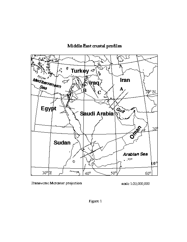
A number of interpretations of seismic refraction and gravity lines from many of the countries of the region have been published. We collected and digitized these cross sections and their locations. A map showing the Middle East refraction and gravity profiles included in our database and several others that will be added in the future is shown in Figure 1. With this digital cross section data, it is possible to obtain gridded surfaces of depth to Moho and depth to basement.
From gravity interpretation publications, we first digitized the locations and the interfaces of the gravity profiles. Then, we converted the lines to distance-depth coordinates in km. Distance along the profile is always measured from the left edge of the cross section and depth is always negative below sea level. Each "arc" or interface is then assigned "attributes" that indicate the density above and below the interface (stored in the Arc Attribute Table or AAT in Arc/Info). At this stage, the cross section is still a separate coverage not geographically registered. Therefore, we can describe this as a two dimensional dataset where the horizontal distances are represented on the x axis and the depth on the y axis. Then, we re-sampled the digitized cross section at 1 km intervals. These simple x-y cross sections are converted into x-z cross sections when depth "z" is computed at one kilometer intervals along the x axis. At the same time, the points are added to the location map, and the attributes (depth and density) are attached to each point. Thus, the third dimension, depth, is stored in info files which can simply be displayed as graphs in ArcInfo or can be used to generate grids.
We digitized seismic refraction results from published literature in a similar way. The profile locations and shot points were digitized and converted to latitude-longitude geographic coordinates. The interfaces of interpreted refraction profiles were digitized and converted into distance-depth coordinates in km then attributes were assigned to each interface to store the velocities above and below the interface in the AAT. Finally, the depth of each interface was re-sampled at one kilometer intervals and the velocities above and below each interface were entered as attributes to the points along the cross section. We do not keep the distance origin used by the authors, which is usually taken to be the location of a shot used for ray-tracing the 2-D velocity model, instead we always take the origin as on the left border of the cross section. A 1-D velocity (or density) versus depth sections at a specific point on the profiles can also be plotted by just selecting the point location along any profile.
Contour maps of depth of the Moho or other crustal structures are digitized in Arc/Info by recording the depth value of each contour as an attribute of the "arc" or contour line. As for all maps, the locations are converted to geographic coordinates by taking known points and estimating the proper map projection parameters to invert the projection used in making the map.
These contour datasets are then converted into grids by using the topogrid command of Arc/Info software. Topogrid uses an iterative finite difference interpolation technique. Based upon the ANUDEM program developed by Hutchinson (1989), this procedure is specifically designed for creating hydrologically correct digital topography. However, it can be used for other purposes like gravity, moho depth, or basement depth grids without drainage restrictions.
Our efforts under this project concentrated on geophysical data on crustal structure, but we plan to add more geological data in the future. Many geologic maps and information on stratigraphy and structure from sources such as drill holes are available throughout the Middle East and North Africa. These data are useful to better understand the tectonic structure and development of the region, and especially useful for mapping the distribution of special geologic units such as salt beds that have a large effect on the generation or propagation of seismic signals. A few of the major tectonic features in the Middle East were digitized at a relatively crude scale suitable for regional maps and are shown on some of the figures in this report.
Under other projects at Cornell, we have acquired some digital satellite imagery for areas of the Middle East, North Africa, and Eurasia. The most extensive coverage are complete sets of Landsat Multispectral Scanner (MSS) images for Syria and Morocco and several Thematic Mapper (TM) images from North Africa and Syria. A big advantage of Landsat MSS scenes is that they are not copyrighted and are freely shareable with other researchers.
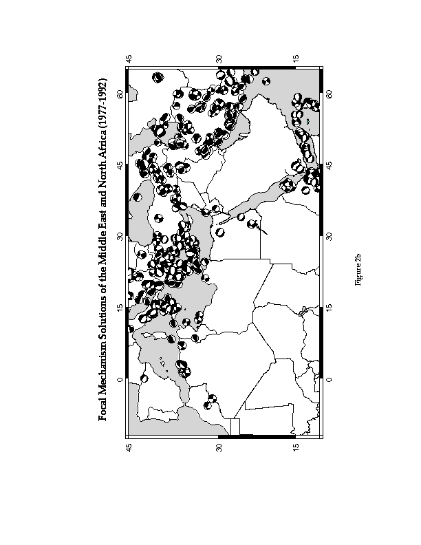
The hypocenters located between 50ˇN 10ˇS and 70ˇE 20ˇW, were extracted from two different sources: the International Seismological Center (ISC) and the United States Geological Survey (USGS). The catalog from the ISC includes events from January 1964 through August 1987, while the one from the USGS includes events from 2000 B.C. through December 1990. Each event in the data base is described according to date, time, latitude, longitude, magnitude, depth, intensity and associated phenomena. An Arc/Info coverage has been generated from the USGS data base (Figure 2a) and the characteristics of each event have been included as separate items in the Point Attribute Table (PAT) of this coverage. Figure 2b shows the Harvard database of focal mechanism solutions in the region of interest. This database includes all earthquakes of magnitudes ł 5.5 .
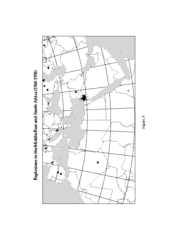
The USGS/NEIC data base includes identified explosions. All the explosions in the Middle East and North Africa region are extracted from the Arc/Info coverage and shown in Figure 3. There are other explosion sites in the region. We are currently working on digitizing newly available database to provide a map of large industrial explosion sites in the Middle East and North Africa.
We are building our bibliographic database (see Appendix II) in the Macintosh program called EndNote. References to books, journal articles, reports and other published literature are stored with the usual information on title, date, authors, journal, page numbers, etc. and with searchable keywords on the content. Automatically (by keyword search) or manually selected subsets of the EndNote dataset can be extracted and formatted in a variety of formats. This is becoming a comprehensive database of crustal structure, geology, and geophysics literature for the Middle East and North Africa, and we have copies of nearly all the references, including many hard-to-find reports, in our files. We continue to add to this bibliographic database, but we are releasing this version now to aid other researchers.
All of the crustal structure databases produced for Europe and Asia under our previous contracts continue to be available via "anonymous ftp" and our raster server. We continue to fill requests for these databases from seismic researchers around the world under ARPA/AFOSR/DOE/AFTAC contracts.
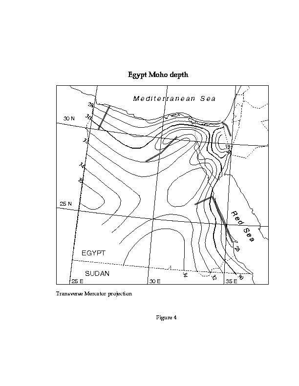
Both gravity and deep seismic refraction data have been collected in Egypt. A dissertation by Marzouk (1988) describes much of the data.
We digitized a contour map of the depth to the Moho that is based on gravity and refraction data (Figure 4). We also digitized a contour map of Bouguer gravity anomalies of this area. Grids have been built by using the topogrid command of Arc/Info.
Most of Egypt has crust 30-33 km thick, but it thins dramatically in the Red Sea rift zone to 20 km or less. Only the beginning of the crustal thinning of the Red Sea rift is shown in Figure 4. Southern and western Egypt has thicker crust reaching more than 35 km, while the northernmost part of Egypt includes part of the transition into the Mediterranean oceanic crust with crust down to 27 km thick at the coastline. The sediment thicknesses increase gradually to the north in Egypt where the large delta of the Nile extends into the Mediterranean.
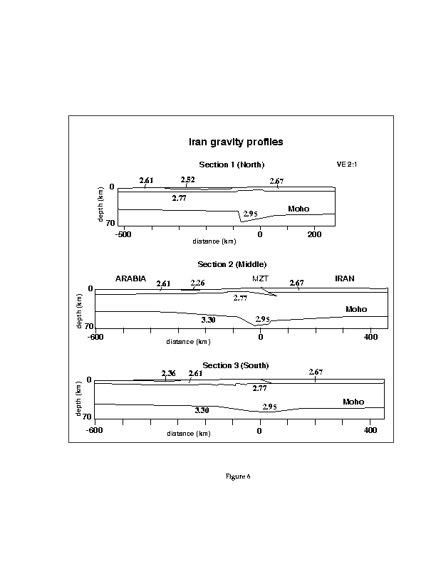
We have begun our database for Iran with the digitization of the crustal structure profiles interpreted from gravity data by Snyder and Barazangi (1986). The locations of the three profiles of crustal density structure, interpreted primarily from gravity, were digitized from the location map and are shown in Figure 5, along with two of the major tectonic features of the area digitized from the same location map, the Main Zagros Thrust (MZT) and the Zagros deformation front.
The profiles are shown together on Figure 6, with a vertical exaggeration. Note that the major change in Moho depth is the crustal root of the high elevation part of the Zagros, in the region of the MZT, which reaches down past 60 km depth. Much of the rest of Iran, the Arabian/Persian Gulf, and northeast margin of the Arabian plate has Moho depths close to 40 km depth.
A Bouguer gravity grid has been built for the Zagros Mountains in Iran, Iraq and nearby regions, from a point data set. In addition, a contour map was generated from this grid. Free air gravity values are also available for the area and the same procedure is in process to obtain both the grid and the contours.
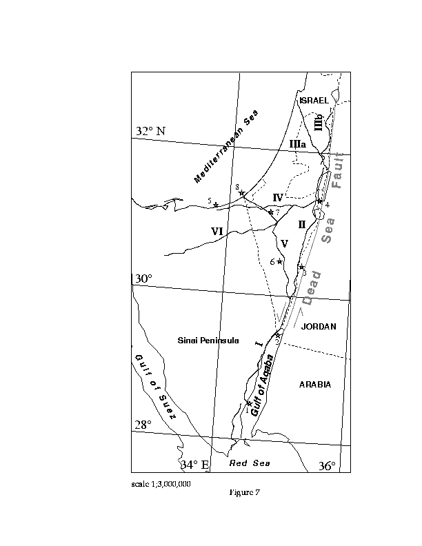
Deep seismic refraction data were collected along six profiles in Israel and occupied territories in 1977 and first described by Ginzburg and others (1979a, b). Large shots in the Dead Sea, Mediterranean, and Gulf of Aqaba provided strong sources. The detailed interpretation of the refraction profiles are described by Ginzburg and Folkman (1980) and Ginzburg and others (1981). In addition, four shorter refraction profiles were shot across central and northern Israel by the Israel National Oil Co., only one of which was long enough to provide data on the deep crust (Ginzburg and Folkman, 1980). The locations of the profiles were digitized and are shown on Figure 7. Also shown on Figure 7 are the locations of the shot points 1-8 used in the 1977 survey. Their naming scheme for refraction receiver lines used line 3 for the longest of the oil exploration profiles and lines I-VI for the 1977 profiles, but to avoid confusion on our figures between shot point numbers and line numbers, we have renamed the line 3 as line IIIa and the 1977 line III as line IIIb. The location of the major tectonic feature in the Israel/Jordan area, the Dead Sea fault system, which forms the margins of the Dead Sea "rift" and marks the "leaky transform" plate boundary between the Arabian Plate to the east and the Mediterranean plate to the west has been digitized and plotted on Figure 7 for reference.
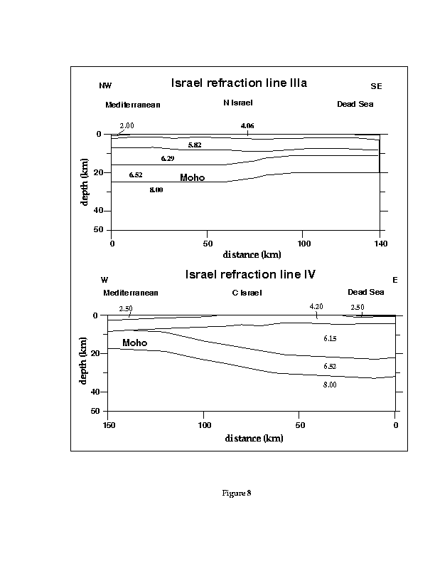
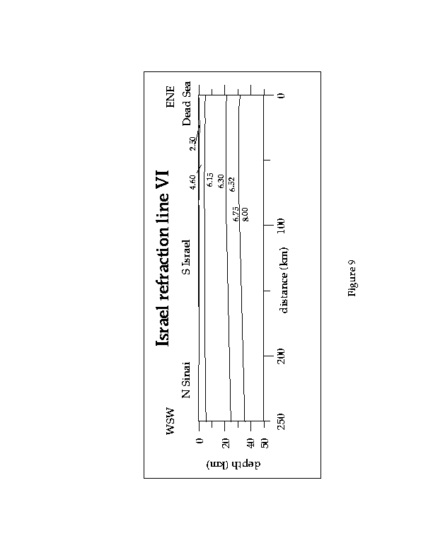
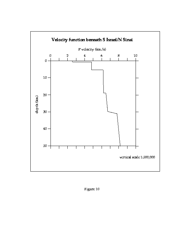
All of the interpreted 1D and 2D velocity structure figures of Ginzburg and Folkman (1980) and Ginzburg and others (1981) have been digitized. The crustal structure of northern and central Israel is shown on Figure 8 by interpretations of the two refraction lines (IIIa and IV) running from the Dead Sea to the Mediterranean (Ginzburg and Folkman, 1980). The structure of the northern Sinai and southern Israel from line VI is shown in Figure 9 (Ginzburg and others, 1981). The depth of the Moho between the Dead Sea and the Mediterranean decreases northward from more than 40 km in the Sinai to less than 25 km in northern Israel. The crustal thickness also decreases and sediment thickness increases towards the Dead Sea and Mediterranean. The one-dimensional velocity-depth function for line VI is shown in Figure 10.
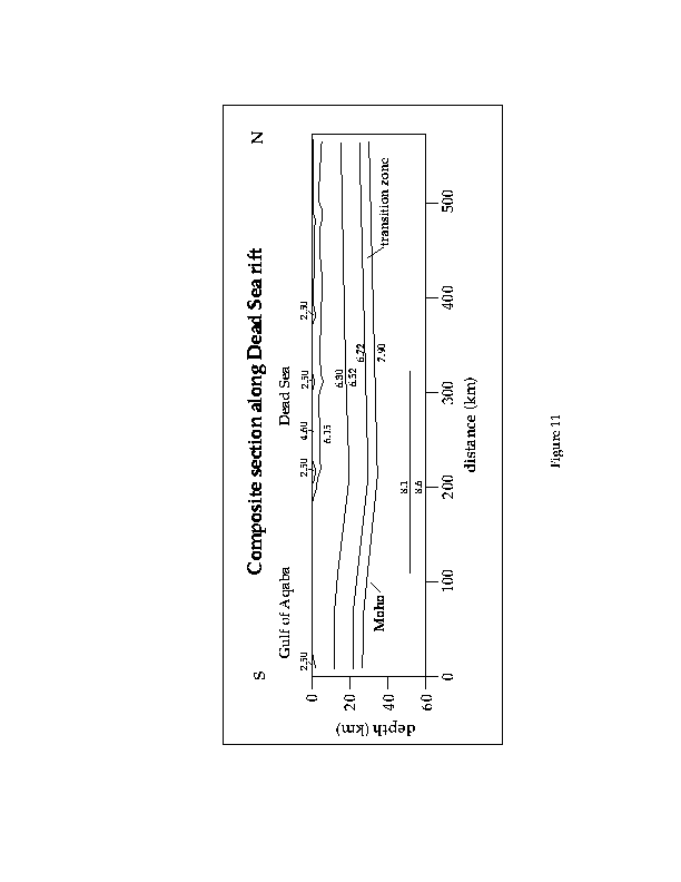
The crustal structure of the Dead Sea "rift" from the Sea of Galilee to the Gulf of Aqaba is shown by the composite section of Figure 11 (from lines I, II, and IIIb) and the profiles of individual ray tracing models (Ginzburg and others, 1981). The large shots at shot point 4 in the Dead Sea provided good records out to long distances. The amplitude variations of secondary arrivals indicate the presence of a 5 km thick transition zone at the base of the crust with a gradation in P velocity from 6.72 to 7.9 km/s, and this zone is interpreted to extend along the entire composite section of the "rift". The depth to the Moho varies slowly from a maximum of about 35 km near Elat to about 27 km on the western margin of the southern Gulf of Aqaba and about 30 km in the north. A one-dimensional velocity-depth function is shown in Figure 12 for the Dead Sea shot point 4 along the "rift".
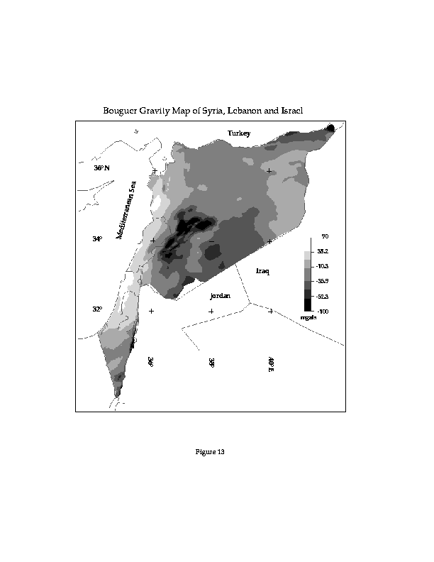
A contour map of Bouguer gravity of Israel has been digitized (Ginzburg and others, 1993) and a grid has been built from it. This grid has been merged with the grids for Lebanon and Syria (Khair and others, 1993; Best and others, 1990) (Figure 13). To be able to append these adjacent grids, the contours have been smoothed and joined through the country borders.
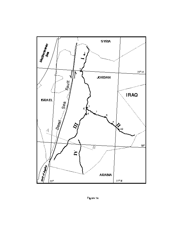
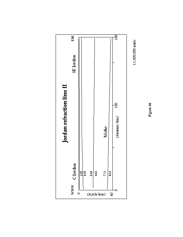
A set of four refraction lines were collected in Jordan in May 1984 by the University of Jordan, Amman with the Institutes of Geophysics of Hamburg and Karlsruhe Universities (El Isa and others, 1987). We have digitized the line and shot-point locations, shown as Figure 14. Also shown on Figure 14 is the location of the Dead Sea fault system. The best long-range refraction results were obtained using large shots at shot-points 1 to 5, with recordings out to 200 km distances at a station spacing of 5 km along lines I to IV. A more detailed short-range dataset was collected along line II with smaller shots at shot-points 6 to 10 with stations out to 30 km distance and a station spacing of 1 to 2 km.
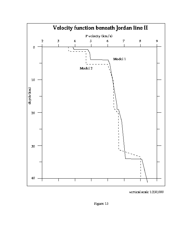
One-, two-, and three-dimensional velocity structures were interpreted and published by El Isa and others (1987), and we have digitized the one- and two-dimensional figures (due to perspective distortion it is not possible to digitize the three-dimensional figure). The one-dimensional velocity-depth functions beneath central Jordan are shown in Figure 15, derived from quarry explosion at shot point 3 and recorded along line II. Model 1 corresponds to the two-dimensional model of Figure 16 and Model 2 corresponds to a reflectivity synthetic seismogram interpretation of the same data. The two-dimensional velocity-depth-distance profiles are shown in Figures 16-18. The depth to Moho is between 30 and 40 km for all of Jordan, shallower to the west (closer to the Dead Sea rift) and deeper to the east. Depth to crystalline basement increases towards the northeast from zero at the Precambrian (Proterozoic) surface outcrops in the southwest corner of Jordan to about 5 km in central Jordan.
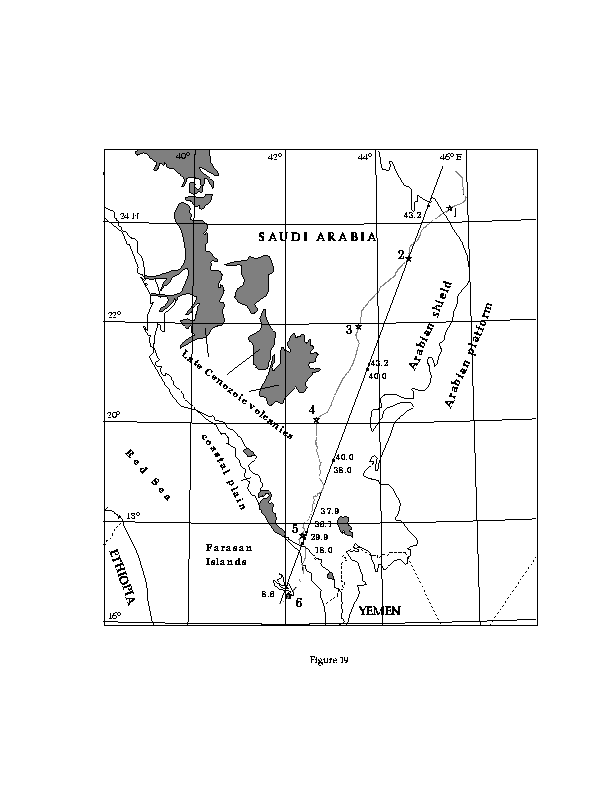
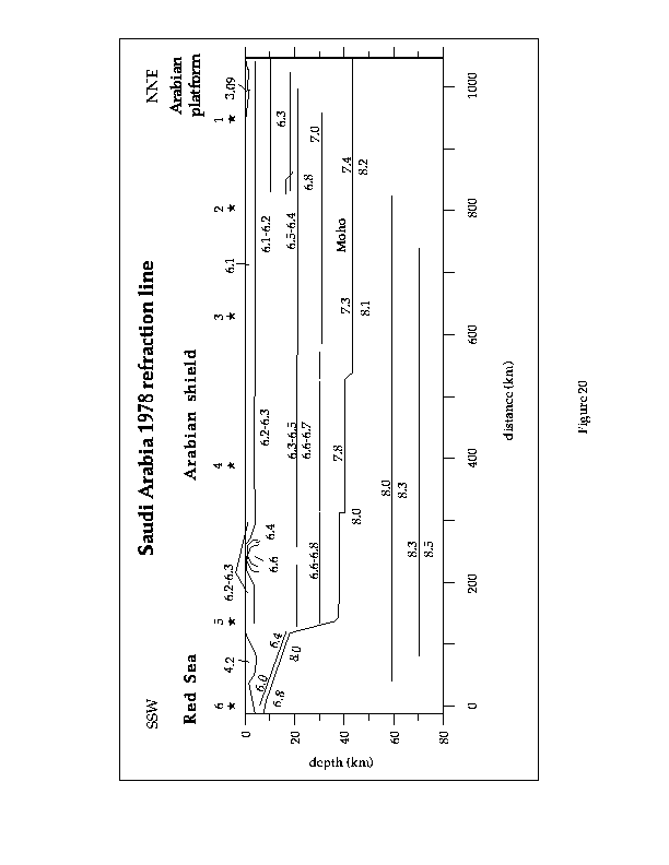
Two deep refraction surveys have been shot in Saudi Arabia, one very long profile was collected across southern Saudi Arabia, and several shorter profiles were collected in NW Saudi Arabia in collaboration with German researchers. The ~1200 km long refraction line from the Farasan Islands in the Red Sea across to the other side of the Arabian Shield in central Saudi Arabia was conducted mostly by the USGS in 1978 (Blank and others, 1979; Healy and others, 1982; Mooney and others, 1985). The locations of the receiver arrays were digitized from the 1:2,000,000 scale map of Plate 7 of Healy and others (1982) and are shown on Figure 19, along with the digitized locations of the seven shot points (two shot points were located close together and are both adjacent to the label 6 on the figure).
An IASPEI workshop was held in 1980 to compare a wide variety of different interpretations of the 1978 refraction profile data and the results were published in a proceedings volume (Mooney and Prodehl, 1984). The interpretations were quite similar in the relatively simple Arabian shield area, but varied widely in the transition into the Red Sea rift where the velocity structure changes rapidly. We chose to start with the interpretation of the USGS group for our database. The large 1:2,000,0000-scale interpreted section in Plate 9 of Healy and others (1982), which is similar to that of Mooney and others (1985), was digitized, converted to distance-depth coordinates in km, and plotted in Figure 20.
The next step was to convert the distance-depth coordinates of the interpreted section (Figure 20; Healy and others, 1982) to geographic coordinates that can be plotted on a map. We selected the interpreted Moho interface from the database, converted the vertices along the Moho to points, and then projected the points onto a strike-line running along the length of the refraction survey to obtain latitude-longitude-depth triplets for points of the Moho. The strike-line and Moho points are shown on Figure 19, with the depth of the points in km below sea level marked next to the point locations. In this interpretation from Healy and others (1982), the steepest slope of the Moho from about 38 km to 18 km depth occurs beneath shot point 5, some 50 km inland of the present Red Sea coastline, near the position of the topographic scarp, the Hijaz-Asir escarpment, that marks the edge of the rift zone and the beginning of the sediments of the coastal plain. On the Arabian shield, where Precambrian basement is exposed, the Moho is close to 40 km deep and the P velocities start over 6 km/s at the surface. At the NNE end of the profile, a thin layer of Phanerozoic sediments cover the basement surface that gently slopes eastward under the Arabian platform.
No deep refraction data have been collected in Syria, but several DSS lines with detailed information on the upper and middle crust were shot. These profiles have been reinterpreted at Cornell (using the original analog seismic recordings) and provide excellent information on the thickness of the sedimentary basins and depth to basement in Syria (Seber and others, 1993). An ongoing Cornell collaboration with the Syrian Petroleum Company has brought to Cornell many other datasets for Syria, including seismic reflection lines, drill hole, and gravity data.
The gravity data have already been digitized and gridded with 1000 meters cell size (Figure 13). We have digitized crustal profiles based on gravity interpretation (Best et al., 1990). Figure 1 shows the location of these profiles.
The contours from a Bouguer gravity map of Lebanon (Khair and others, 1993) have been digitized. From this Arc/Info coverage a grid has been built with 1000 meters cell size. The contours were appropriately joined to that from Syria and Israel so the appended Syria-Lebanon-Israel grid does not show abrupt changes in the country borders due to differences in resolution in adjacent maps (see Figure 13). We have also digitized three crustal profiles based on gravity interpretation (Figure 1). No refraction profiles are available in Lebanon.
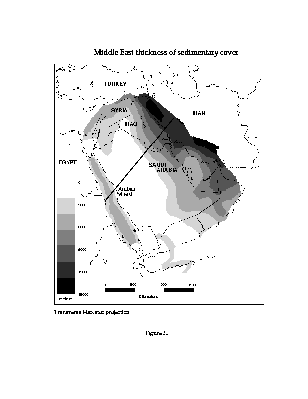
We have digitized a preliminary map of the thickness of sedimentary cover for most of the Middle East (Figure 21). This map was prepared by Beydoun (1989) and shows the major variations in sedimentary thickness for the area. The western part of the Arabian plate, the Arabian shield, has Precambrian basement exposed at the surface, and the basement slopes eastward under sediments up to 45,000 ft (~14 km) thick in the Zagros. To the west of the Arabian shield, a steep scarp forms the edge of the Red Sea rift zone with up to 15,000 ft (~4.5 km) of sediments. This map should only be used to get an overall view of the sediment thicknesses. We converted the depths to metric units and generated a grid from these contours (Figure 21). A better gridded surface will be generated from the refraction and gravity cross sections, and available wells. Two grids, the basement and the topography, are subtracted one from the other in order to obtain the thickness of the sedimentary layer. Figure 22 shows an example of a cross section across the Arabian plate showing surface topography and seismic basement. The very thick sedimentary cover in the Mesopotamian foredeep could significantly affect the propagation characteristics of high- frequency crustal seismic phases, such as Pg and Lg.
An extensive point dataset of Bouguer and free air gravity values from the Bureau Gravimetrique International (BGI), allowed the generation of a gravity grid of North Africa. The density of the spatial distribution of the data varies considerably for different areas. The best represented countries are Morocco and Egypt. These grids have been generated with 1000 meters cell size for small areas and then merged together by using the ArcInfo Grid function, mosaic. It uses a weighted average method on the overlapping areas giving smooth transition. Moreover, we expect to include considerably more geophysical and geological databases for North Africa in our database, including refraction profiles in Morocco, and detailed seismicity catalog for northwest Africa and southern Iberia.
The Digital Chart of the world is a 1:1,000,000 scale basemap of the world published by the USGS. This database is originally divided in 5ˇ by 5ˇ tiles. The tiles have been appended together as well as their arc, point, and polygon attribute tables in a region covering the Middle East and North Africa. These descriptive attributes are codes in the individual tiles (i.e., popytype = 1 indicates land, and popytype = 2 indicates oceans). However, after appending the tiles, new character-type items were added, describing the code numbers for each attribute table. The following layers are available: "Drainage", "Physiography", "Political and Oceans", "Populated place", "Roads, Railroads and Transport Structure" and "Utility". The coverage with the country borders ("political and oceans") will be updated soon for countries like the former Yugoslavia and Soviet Union by digitizing the new country borders and replacing them only were changes have occurred.
Under our World Wide Web (WWW) server, a profile maker and a focal mechanism map maker have been developed. These tools can be accessed through a client software such as Mosaic or Netscape. In order to obtain a cross section including topography, basement, and moho, the user enters the coordinates of two or more arbitrary points and the program computes the cross section by "slicing" the available grids along great circle paths and presents the results both in hardcopy and ASCII text files.
We are using the Harvard CMT data for the focal mechanism map maker. It includes events from 1977 to 1994 globally. If a rectangular region is defined, the available focal mechanisms are selected and displayed. It is also possible to download the selected events with all their attributes.
We are releasing our developed databases in several different forms, all accessible over the Internet. We are now using the well-established anonymous FTP protocol, however our main focus now is the World-Wide Web (WWW) protocol that is rapidly increasing in popularity on the Internet due to its more sophisticated functions. Our Web address is "http://www.geo.cornell.edu/geology/me_na/main.html".
Our anonymous FTP server is hugo.geo.cornell.edu and the data are stored in the pub/arpa directory and subdirectories. There is a new subdirectory pub/arpa/mideast with further subdirectories below that for each country described above. We are releasing the data in several different forms on our Web server, the finished figures of this report in PostScript and Adobe Illustrator form, and the raw data in flat ASCII files as extracted from Arc/Info are also available. The PostScript files (with the ".ps" suffix) can be printed on PostScript printers. The Adobe Illustrator files (with the ".ai" suffix) can be read by drawing and page layout programs that can handle Illustrator v. 5 format files. The raw data files have several different formats for different types of information, and the file formats are explained in Appendix I (below) and in "README" files for each type available on the FTP server. Please address all questions, comments, and suggestions on the format and content of our network database to "seber@geology.cornell.edu".
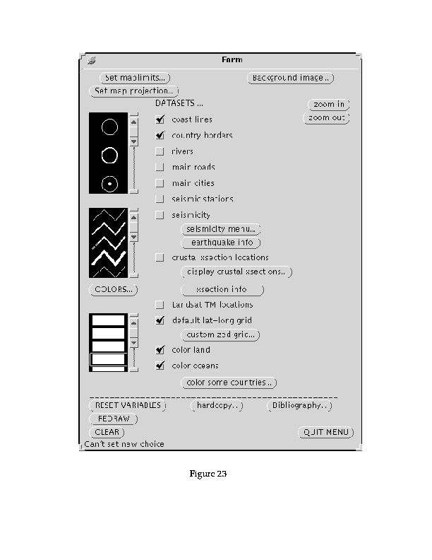
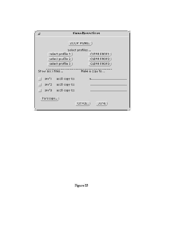
We have been building a new menu system for display and query of our database. This new user interface is designed to permit an easy and efficient access to our databases with no need of knowing ArcInfo. This menu allows the user to select specific geographic features for display like country borders, rivers, etc., As well as search and query our databases. The main menu is shown in Figure 23. Some features have been selected in this menu for display by simply clicking on them. Thus, the land and the oceans are shaded and the coast lines, country borders and a latitude-longitude grid displayed (see Figure 24). The little, square boxes are called "check boxes". By simply checking the boxes the user have access to the coverages and there is no need to type any commands. The small scrolling windows contain point, line and shade symbols which can be selected to switch the default ones if they do not satisfy the user. The other kind of buttons launch other menus if they end with three points "...", Or simply perform an action like the quit button which quits the entire menu. As an example, the "display crustal cross section button" (see Figure 25), is another menu which allows the user to select a cross section location by clicking on "select profile1", and then selecting the profile of interest interactively on the screen. The menu then displays the profile next to the location map. It is also possible to obtain numerical values in ASCII files or print the profiles. The cross sections are displayed with density or velocity information for each interface (see Figure 26). Another important feature in the main menu is the "xsection info" button which permits the user to obtain the references about a particular profile, these include author name, year of publication and journal name, etc.
The "seismicity menu ..." actually launches a submenu which can also launches another submenu. The first menu launched is shown in Figure 27a. Selections using Mb or Ms magnitude ranges, depth ranges, or time intervals can be easily performed with this menu. The button "selecting by the type of phenomena..." launches the second submenu (see Figure 27b), which allows the user to make a selection according to the type of event. Many events in the database have not been identified, but any event that was identified as an explosion, for example, will be displayed if that selection is done (see Figure 3). In the main menu (see Figure 23), there is a button, "earthquake info" which gives the user all the information about an event selected with the mouse from the screen once the seismicity of an area is displayed.
There are other menus and submenus which allow to display grids, Landsat TM imagery, change the projection of maps, shade some countries with a different color, or display the bibliography. It will be possible soon to obtain cross sections between any two arbitrary points where grids like moho depth, basement depth, and topography are available. This feature is already available through our "profile maker" on our Web server described in section 3.5. This user interface not only makes things easier for the user but also it is very simple to update when new data are available. In addition, new features like an ArcInfo profile maker, can be easily implemented without major modifications to the existing menu.
Best, J. A., M. Barazangi, D. Al-Saad, T. Sawaf, and A. Gebran, Bouguer gravity trends and crustal structure of the Palmyride mountain belt and surrounding northern Arabian platform beneath Syria, Geology, 18, 1235-1239, 1990.
Beydoun, Z.R., Hydrocarbon potential of the deep (pre-Mesozoic) formations in the Middle East Arab countries, in Technical Papers Presented at the Seminar on Deep Formations in the Arab Countries: Hydrocarbon Potential and Exploration Techniques, Abu Dhabi National Oil Company, Abu Dhabi, UAE, 1989.
Blank, H.R., J.H. Healy, J.C. Roller, R. Lamson, F. Fischer, R. McClearn, and S. Allen, Seismic refraction profile, Kingdom of Saudi Arabia, field operations, instrumentation, and initial results, U.S. Geological Survey Saudi Arabian Mission Project Report 259, 49 p., 1979.
El-Isa, Z., J. Mechie, C. Prodehl, J. Makris, and R. Rihm, A crustal structure study of Jordan derived from seismic refraction data., Tectonophysics, 138, 235-253, 1987.
Fielding, E.J., Barazangi, M., and Isacks, B.L., A geological and geophysical database for Eurasia, Final Technical Report, ARPA NMRO #F29601-91-K-DB08, Cornell University, Ithaca, NY, 38 p., 1993.
Ginzburg, A., and Y. Folkman, The crustal structure between the Dead Sea Rift and the Mediterranean Sea, Earth Planet. Sci. Lett., 51 (1), 181-188, 1980.
Ginzburg, A., Y. Folkman, M. Rybacov, Y. Rotstein, R. Assael, and Z. Yuval. Israel, Bouguer Gravity map. The Institute for Petroleum Research and Geophysics, 1993.
Ginzburg, A., J. Makris, K. Fuchs, and C. Prodehl, The structure of the crust and upper mantle in the Dead Sea Rift., Tectonophysics, 80, 109-119, 1981.
Ginzburg, A., J. Makris, K. Fuchs, C. Prodehl, W. Kaminski, and U. Amitai, A seismic study of the crust and upper mantle of the Jordan-Dead Sea rift and their transition toward the Mediterranean Sea, J. Geophys. Res., 84 (B4), 1569-1582, 1979a.
Ginzburg, A., J. Makris, K. Fuchs, B. Perathoner, and C. Prodehl, Detailed structure of the crust and upper mantle along the Jordan-Dead Sea rift, J. Geophys. Res., 84 (B10), 5605-5612, 1979b.
Healy, J.H., W.D. Mooney, H.R. Blank, M.E. Gettings, W.M. Kohler, R.J. Lamson, and L.E. Leone, Saudi Arabian seismic deep-refraction profile: Final project report, U. S. Geological Survey Open-File Report USGS-OF-02-37, 370 p., 9 plates, 1982.
Hutchinson, M.F., A new procedure for gridding elevation and stream line data with automatic removal of spurious pits. Journal of Hydrology, 106, 211-232, 1989.
Khair, K., M. Khawlie, F. Haddad, M. Barazangi, D. Seber, and T. Chaimov, Bouguer gravity and crustal structure of the Dead Sea transform fault and adjacent mountain belts in Lebanon, Geology, 21, 739-742, 1993.
Makris, J., R. Rihm, and A. Allam, Some geophysical aspects of the evolution and structure of the crust in Egypt, in El-Gaby, S., and R.O. Greiling (Eds.), The Pan-African Belt of Northeast Africa and Adjacent Areas, Friedr. Vieweg & Sohn, Braunschweig, p. 345-369, 1987.
Marzouk, I. A., Study of crustal structure of Egypt deduced from deep seismic and gravity data, Ph.D. dissertation, University of Hamburg, 118 p., 1988.
Mooney, W. D., and Prodehl, C. (eds.), Proceedings of the 1980 workshop of the International Association of Seismology and Physics of the EarthŐs Interior on the seismic modeling of laterally varying structures: Contributions based on data from the 1978 Saudi Arabian refraction profile, U.S. Geological Survey Circular 937, 158 p., 1984.
Mooney, W. D., M. E. Gettings, H. R. Blank, and J. H. Healy, Saudi Arabian seismic-refraction profile; a traveltime interpretation of crustal and upper mantle structure, Tectonophysics, 111 (3-4), 173-246, 1985.
Seber, D., M. Barazangi, T. Chaimov, D. Al_saad, T. Sawaf and M. Khaddour, Upper crustal velocity structure and basement morphology beneath intracontinental Palmyride fold-thrust belt and north Arabian platform in Syria, Geophys. J. Int., 113, 752-766, 1993.
Snyder, D. B., and M. Barazangi, Deep crustal structure and flexure of the Arabian Plate beneath the Zagros collisional mountain belt as inferred from gravity observations, Tectonics, 5 (3), 361-373, 1986.