My dissertation research comprises an interdisciplinary study of intracontinental deformation in Atlas Mountains of Morocco as part of the Cornell Morocco Project. My dissertation is entitled "Late Cenozoic Tectonics Of The Middle Atlas Mountains, Morocco: Continental Deformation In The Diffuse Western Mediterranean Plate Boundary." I am working under the supervision of Dr. Muawia Barazangi (tectonics) , Dr. Rick Allmendinger (structural geology), and Dr. William Philpot (remote sensing) here at Cornell.
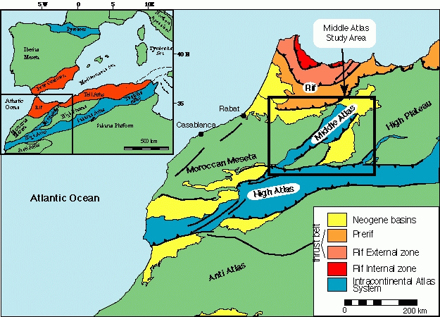
Intracontinental mountains represent an important aspect of the tectonic processes. These mountains lack many of the features commonly associated with plate-boundary mountains systems, and frequently occur along inherited zones of crustal weakness. Ultimately, we seek to understand why such mountains evolve and what is the relation between plate-boundary mountain belts and those that develop within the continent. The Atlas of North Africa is an excellent example of and intracontinental mountain belt. This 2000 km long mountain chainextends from the Atlantic coast of Morocco across North Africa to the Mediterranean coast of Tunisia and represents a significant degree of deformation occurring up ot 500 km into the foreland of the collisional zone.
I have been focussing on the Middle Atlas region of Morocco (shown by the box on the map above) in an effort to constrain the kinematics of Late Cenozoic tectonism. The Middle Atlas Mountains are a critical piece to understanding the larger puzzle of intracontinental deformation in north Africa. These mountains are peculiar in several aspects including the occurence of mafic volcanism within a compressional setting and the lack of crustal root for the 2-3 km topography. Due to the oblique orientation of the Middle Atlas with respect to the Late Cenozoic stress field of the western Mediterranean, it is generally believed that the mountain system is in a transpressive environment, thus raising the issue of the role of strike-slip faulting. New information on the Middle Atlas is being incorporated with existing information from the better-studied regions of High Atlas and the Rif Mountains in an effort to analyze the big picture.
The research incorporates techniques from structural geology (microtectonics, balanced cross-sections, field mapping), geophysics (seismic reflection analysis), neotectonic geomorphology, and remote sensing (satellite and aerial photography) with kinematic and geodynamic modeling. Different spatial databases are maintained using GIS technology. The research is currently supported by a grant from the National Science Foundation.
To date, the main results of this research have demonstrated interesting kinematic variations within the Middle Atlas system. Of particular interest is a partitioning of deformation between strike-slip faulting in the northwest and thrust faulting and folding within the folded mountain belt. Furthermore, I have been developing a model involving vertical partitioning of deformation within the fold belt in order to reconcile estimates of horizontal shortening and crustal thickening. In addition, evidence for recent tectonism has been documented through the analysis of stream profiles and digital elevation models (DEMs) and from observations of fault scarps in the field.
Last modified March 8, 1999.